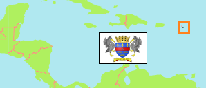
Saint-Barthélemy separated from Guadeloupe in 2007.
Statistical Areas
The population of Saint-Barthélemy and its statistical areas according to census results and latest official estimates.
| Name | Abbr. | Area A (hect) | Population Census (C) 1982-03-09 | Population Census (C) 1990-03-15 | Population Census (C) 1999-03-08 | Population Estimate (E) 2006-01-01 | Population Estimate (E) 2010-01-01 | Population Estimate (E) 2016-01-01 | Population Estimate (E) 2020-01-01 | Population Estimate (E) 2021-01-01 | |||
|---|---|---|---|---|---|---|---|---|---|---|---|---|---|
| Saint-Barthélemy | BLM | 2,100 | 3,059 | 5,038 | 6,852 | 8,256 | 8,938 | 9,793 | 10,457 | 10,464 | |||
| Au Vent [Windward] | AVT | 1,160 | ... | ... | ... | 3,108 | 3,447 | 3,784 | 4,039 | ... | 1160 | ||
| Centre | CEN | 340 | ... | ... | ... | 2,299 | 2,615 | 2,797 | 2,986 | ... | 340 | ||
| Sous le Vent [Leeward] | SLV | 590 | ... | ... | ... | 2,849 | 2,876 | 3,212 | 3,432 | ... | 590 |
- Institut National de la Statistique et des Etudes Economiques, France (web).
Contents: Capital
The population development of the capital of Saint-Barthélemy according to official estimates.
| Name | Status | Population Estimate (E) 2006-01-01 | Population Estimate (E) 2010-01-01 | Population Estimate (E) 2016-01-01 | Population Estimate (E) 2020-01-01 | Area | |
|---|---|---|---|---|---|---|---|
| Gustavia (Saint-Barthélemy Centre) | Ward | 2,299 | 2,615 | 2,797 | 2,986 | 0 |
- Institut National de la Statistique et des Etudes Economiques, France (web).
Population Structure
Further information about the population structure.
| Gender (E 2020) | |
|---|---|
| Males | 5,553 |
| Females | 4,904 |
| Age Groups (E 2020) | |
|---|---|
| 0-15 years | 1,592 |
| 18-59 years | 7,877 |
| 60+ years | 988 |
| Age Pyramid (E 2020) | |
|---|---|
| 90+ years | 36 |
| 80-89 years | 189 |
| 70-79 years | 440 |
| 60-69 years | 777 |
| 50-59 years | 1,622 |
| 40-49 years | 1,896 |
| 30-39 years | 1,840 |
| 20-29 years | 1,688 |
| 10-19 years | 879 |
| 0-9 years | 1,090 |
